 Koloruj
starsze
nowsze
oceń zdjęcie | skomentuj ocenę | 8 głosów | średnia głosów: 6
 | Polska › woj. opolskie › Opole › Mapy i plany |
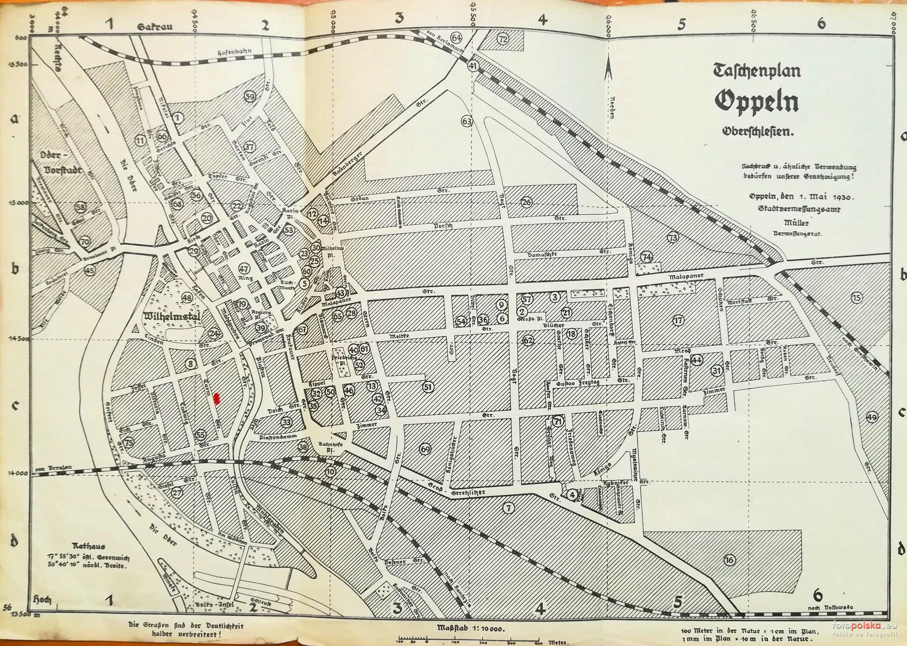
1930 , Mapa Opola z przewodnika Oppeln Regierungshauptstadt der Provinz Oberschlesien. Opisy w komentarzu.
Skomentuj zdjęcie
Niko
+1 głosów:1  1. Amts u Landgericht 2. Arebeitsamt 3. Berufsamt Wohlfahrtsamt 4. Eichamt 5. Feuerwache 6. Finanzamt 7. Guterbahnhof 8. Handelskammer 9. Handwerkskammer 10. Hauptbahnhof 11. Hauptzollamt 12. Hochbauamt Staatlich 13. Kalk und Zementzentrale 14. Schultheis Patzenhofer Brauerei 15. Sagewerk Oesterreich 16. Zement Fabrik Stadt Oppeln 17. Kaserne Reichswehr Kaserne Schutzpolizei Kaserne 18. Katasteramt Postamt 4 Wohnungsfursorge 19. Evangelische Kirche 20. Katholische Pfarramt hl.Kreuz 21. Katholische Kirche Peter Paul 22. Sebastianskirche 23. St.Adalbert Kirche 24. Synagoge 25. Adalbert Hospital inn. Abt 26. Adalbert Hospital chir. Abt 27. Gieselstift 28. Hebammen Lehranstalt u Frauen Klinik 29. St.Alexius Hospital 30. Weisenhaus 31. Kommandantur 32. Kreis Bauamt Kreis Girokasse 33. Kulturamt Kulturbauamter Reichsbahndirektion 34. Landgesellschaft 35. Landratsamt 36. Landwirtschaftskammer 37. Museum 38. Oberpostdirektion Postamt 1 39. Oberprasidium Regierung 40. Oberversicherungsamt 41. Ostbahnhof 42. Polizei Prasidium 43. Polizai Revier I 44. Polizai Revier II 45. Postamt 2 - Postamt 3 Sacrau 46. Provinz Schulkollegium 47. Rathaus Stadtliche Verkehrsamt 48. Regierung Neubau 49. Reichsbahnwerkstatt 50. Reichsbank 51. Schlachthaus 52. Evangelische Schule 53. Gymnasium 54. Handels und Berufsschule 55. Haushaltungsschule 56. Katholische Schule 1 57. Katholische Schule 3/5 58. Katholische Schule 4 59. Katholische Schule 2 - Katholische Schule 6 60. Kloster Lyzeum 61. Oberlyzeum 62. Oberrealschule 63. Realgymnasium 64. Stadion 65. Stadtbauamt, Vermessungamt 66. Stadtheim, Stadtkuche 67. Stadtliches Betriebsamt Stadtliches Betriebskasse Stadtliches Girokasse 68. Stadtliches Elektrizitatswerk 69. Stadtliches Gaswerk 70. Stadt Girokasse, Zweigstelle 1 71. Stadt Girokasse, Zweigstelle 2 72. Stadtliche Wasseerwerk 73. Telegraphen Bauamt 74. Versorgungsamt 75. Wasserbauamt 2017-11-04 18:42:41 (8 lat temu)
do Niko: Bardzo ciekawa legenda mapy! Niko, czy w opisach budynków, instytucji miejskich, gmachów, itp. natrafiłeś na skrót, określenie: "WoFo"? Strasznie nie potrafię rozwiązać co mogło znaczyć. 2017-11-04 19:28:43 (8 lat temu)
do Oderstr.: WoFo powinno być chyba pod numerem 18. 2017-11-04 21:56:23 (8 lat temu)
do krzysztal: Też myślałem czy WoFo to nie czasem WoSo i skrót od Wohnungfursorge.. W gotyku S jest często mylone z F. 2017-11-04 22:03:23 (8 lat temu)
|
|
Na stronie od 2014 październik
11 lat 7 miesięcy 20 dni |
Dodane: 4 listopada 2017, godz. 17:17:47
Źródło: Zbiory Prywatne
Rozmiar: 1800px x 1282px
Aparat: WAS-LX1
1 / 33sƒ / 2.2ISO 2504mm
17 pobrań 1654 odsłony 6 średnia ocen
Poprzednie i następne zdjęcia Niko
Obiekty widoczne na zdjęciu
Mapy i plany
więcej zdjęć (288)